Markets we serve

Transportation

DAS is a proven leader in delivering tailored geospatial solutions to the transportation sector, from highways and roads to rail and transit systems.
Download brochure

Recently completed projects // View all projects

SH 17 In West Texas

DAS Acquired 5cm imagery and 30ppsm LiDAR data for a 53.3 mile section of highway in west Texas, including Aerial Triangulation, LiDAR data processing, Stereo Compilation of all visible surface improvements and breaklines, DTM of LiDAR bare earth points and photogrammetric breaklines, and supplemental field data merger. Deliverables included 1" = 40' Planimetric mapping in 2D and 3D MicroStation V8I, Statement of Map Accuracy, Ground Truthing QC Report, Aerial Imagery and/or LiDAR flight Certification(s), 3D 1-Ft contour data in MicroStation V8I, 3D DTM (includes 3D planimetric features) in MicroStation V8I, TIN data in GeoPak, 0.25-Ft ground resolution digital orthophotography in enhanced compression wavelet (ECW), Orthophoto index map in DGN, KMZ, and PDF format showing the location of each orthophoto panel, Bare Earth LiDAR point file in LAS, and LiDAR Calibration Report.

SH 380 and Spur 399 In North Texas

DAS Acquired 5cm imagery and 30ppsm LiDAR data for a 76 mile section of highway in north Texas, including Aerial Triangulation, LiDAR data processing, Stereo Compilation of all visible surface improvements and breaklines, DTM of LiDAR bare earth points and photogrammetric breaklines, and supplemental field data merger from 3 surveyors. Deliverables included 1" = 40' Planimetric mapping in 2D and 3D MicroStation V8I, Statement of Map Accuracy, Ground Truthing QC Report, Aerial Imagery and/or LiDAR flight Certification(s), 3D 1-Ft contour data in MicroStation V8I, 3D DTM (includes 3D planimetric features) in MicroStation V8I, TIN data in GeoPak, 0.25-Ft ground resolution digital orthophotography in enhanced compression wavelet (ECW), Orthophoto index map in DGN, KMZ, and PDF format showing the location of each orthophoto panel, Bare Earth LiDAR point file in LAS, and LiDAR Calibration Report.

FM 60 In East Texas

DAS Acquired 5cm imagery and 60ppsm LiDAR data covering 206 acres, including Ground survey and aerial targeting, Aerial Triangulation, LiDAR data processing, Stereo Compilation of all visible surface improvements and breaklines, DTM of LiDAR bare earth points and photogrammetric breaklines, and supplemental field data merger from 3 surveyors. Deliverables included 1" = 40' Planimetric mapping in 2D and 3D MicroStation V8I, Statement of Map Accuracy, Ground Truthing QC Report, Aerial Imagery and/or LiDAR flight Certification(s), 3D 1-Ft contour data in MicroStation V8I, 3D DTM (includes 3D planimetric features) in MicroStation V8I, TIN data in GeoPak, 0.25-Ft ground resolution digital orthophotography in enhanced compression wavelet (ECW), Bare Earth LiDAR point file in LAS, and LiDAR Calibration Report.

Our Transportation Solutions

Analysis & Analytics

DAS Geospatial provides expert data processing and analysis for many industries. Our geospatial solutions include engineer-design level maps, LiDAR classification and feature extraction, point cloud colorization, and a wide variety of industry-specific analytics, from transportation to mines and landfills.

Survey Services

DAS Geospatial provides expert aerial survey services for any industry. Our geospatial solutions include GPS ground control surveys, topographic surveys, terrestrial LiDAR, and bathymetric surveys.

Aerial Mapping

DAS Geospatial provides expert aerial mapping for any size project and industry. Our geospatial solutions include design-level maps, digital orthophotography, contour maps, planimetric maps, GIS feature collection, DEM/DTM, basemaps, corridor maps, 3D animated fly throughs, vegetation maps, and facility mapping.

Aerial LiDAR

DAS Geospatial provides expert aerial LiDAR for commercial, industrial, and transportation applications. Our geospatial solutions include end-to-end LiDAR data acquisition from mobile and terrestrial platforms complete with data processing and engineer design level point clouds.

Aerial Photography

DAS Geospatial provides expert aerial photography for any industry. Our aerial photography solutions include oblique imagery, near-infrared imagery, aerial video, thermal imagery, and construction progress imagery.

Transportation Use Cases

We are relied on by state agencies and leading engineering firms throughout the United States to deliver design level solutions for the construction, expansion, or improvement of highways, rail lines, and transit infrastructure. Leverage DAS for your next transportation infrastructure project and other aerial mapping and survey requirements, including corridor mapping and route alignment analysis.

TxDOT Pre-Certified

DAS performs ongoing work for major state transportation agencies and is pre-certified to accelerate your project. Our Texas Department of Transportation (TxDOT) certifications include 15.3.1 Aerial Mapping, 15.3.6 Airborne LiDAR, 15.3.4 Mobile LiDAR, and 15.3.2 Terrestrial Photogrammetry.

A Legacy of Innovation

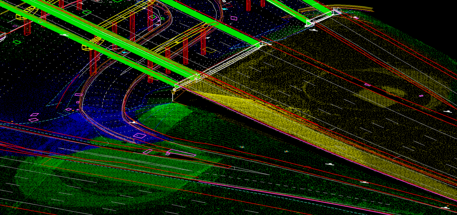
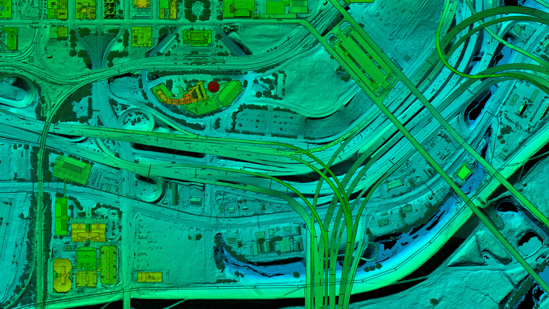
For more than 45 years, DAS has continuously incorporated the latest technologies to deliver best-in-class geospatial solutions for our transportation clients, from fixed wing, helicopter, UAV, and ground-based platforms to data processing, analytics, and engineer design level mapping. DAS provides aerial imagery, LiDAR data collection, and digital orthophotography to empower you to drive infrastructure engineering designs and decisions with high quality topographic maps, planimetric feature extraction and attribution, digital terrain models, remote sensing, and more.