DAS sets the bar in delivering engineer design level mapping. By incorporating sUAS technology into our geospatial platform, DAS is able to optimize the efficiency of sUAS services, while continuing to maintain our high standard of precision mapping.
DAS implements the following steps in order to accurately assess, acquire, and process our UAV’s high-resolution imagery:
Flight Planning Process
- Assess the mission area: DAS determines what airspace restrictions, if any, must be accounted for and addressed. The intended terrain or site to be flown is analyzed in order to establish the most efficient flight procedure.
- Determining flight parameters: Before images are taken, DAS takes the steps to determine and set certain parameters in our mission planner application. These parameters include: identification and specification of take-off and landing sites, weather conditions, flight height, number of flight lines, image overlap, etc.
- UAV operation: Once the above pre-flight preparations are completed, the flight plan can be uploaded to the UAV for project execution.
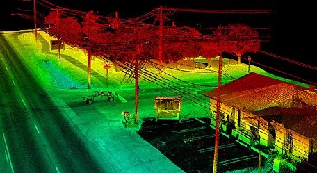
Ground Control Points (GCP)
GCP’s are physically marked locations with a fixed position where coordinates are recorded, increasing accuracy in the X-Y and Z axes. DAS determines where and how much ground control is necessary to obtain the highest amount of accuracy during the UAV flight acquisition and establishes GCP’s on the proposed site prior to the flight. By setting GCP’s, the geometric accuracy of the images are much improved, enabling DAS to accurately scale the project in all three axes and provide 3D measurements to our clients.
Expert Data Processing
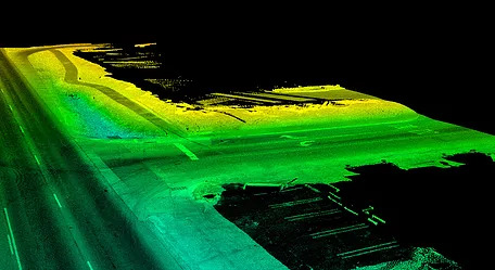
Expert processing of the acquired imagery is a critical step to the overall accuracy and resolution of the final deliverable. DAS’ production staff maps the acquired data to meet the specific scope of our client’s project. Our data mapping process offers accurate and current land representation derived from the following photogrammetric processes and deliverables: Aerial Triangulation, Topography, Orthophotography, Planimetric Features, DSM, DTM, DEM, and LiDAR.
Project Accuracy Comparison Study
In a recent project flown by DAS, the UAV imagery was processed via two different methods: (1) a typical “push button workflow” (i.e. Pix4D), and (2) through DAS’ established photogrammetric workflow. The study compared the point clouds generated from each method against 14 survey control points. In Figure 1., the table highlights the importance of following a meticulously developed data processing workflow in order to maintain design level accuracy.
| Control | Pix4D | DAS Processing |
|---|---|---|
| 1 | n/a* | .222ft |
| 2 | 4.281ft | 0.103ft |
| 3 | 0.093ft | 0.048ft |
| 4 | 1.88ft | 0.024ft |
| 5 | 0.385ft | 0.021ft |
| 6 | 0.0ft | 0.68ft |
| 7 | 0.447ft | 0.057ft |
| 8 | 0.224ft | 0.333ft |
| 9 | 0.085ft | 0.062ft |
| 10 | 0.054ft | 0.073ft |
| 11 | 0.847ft | 0.012ft |
| 12 | 1.579ft | 0.066ft |
| 13 | 1.002ft | 0.021ft |
| 14 | 2.633ft | 0.076ft |
| Avg | 1.03923ft | 0.06328ft |
*Overlap was not sufficient for Pix4D.
About DAS
DAS performs UAS projects for a range of public and private sector clients including transportation, water/wastewater, municipalities, utilities, wind, land development, and landfills/mines. Our expert flight crews include licensed FAA Part 107 pilots, trained flight observers, and geospatial support staff specializing in UAS processing. We use both rotary and fixed-wing UAS aircraft that can be equipped with digital cameras and other sensors to support various client applications.